Built for Walking
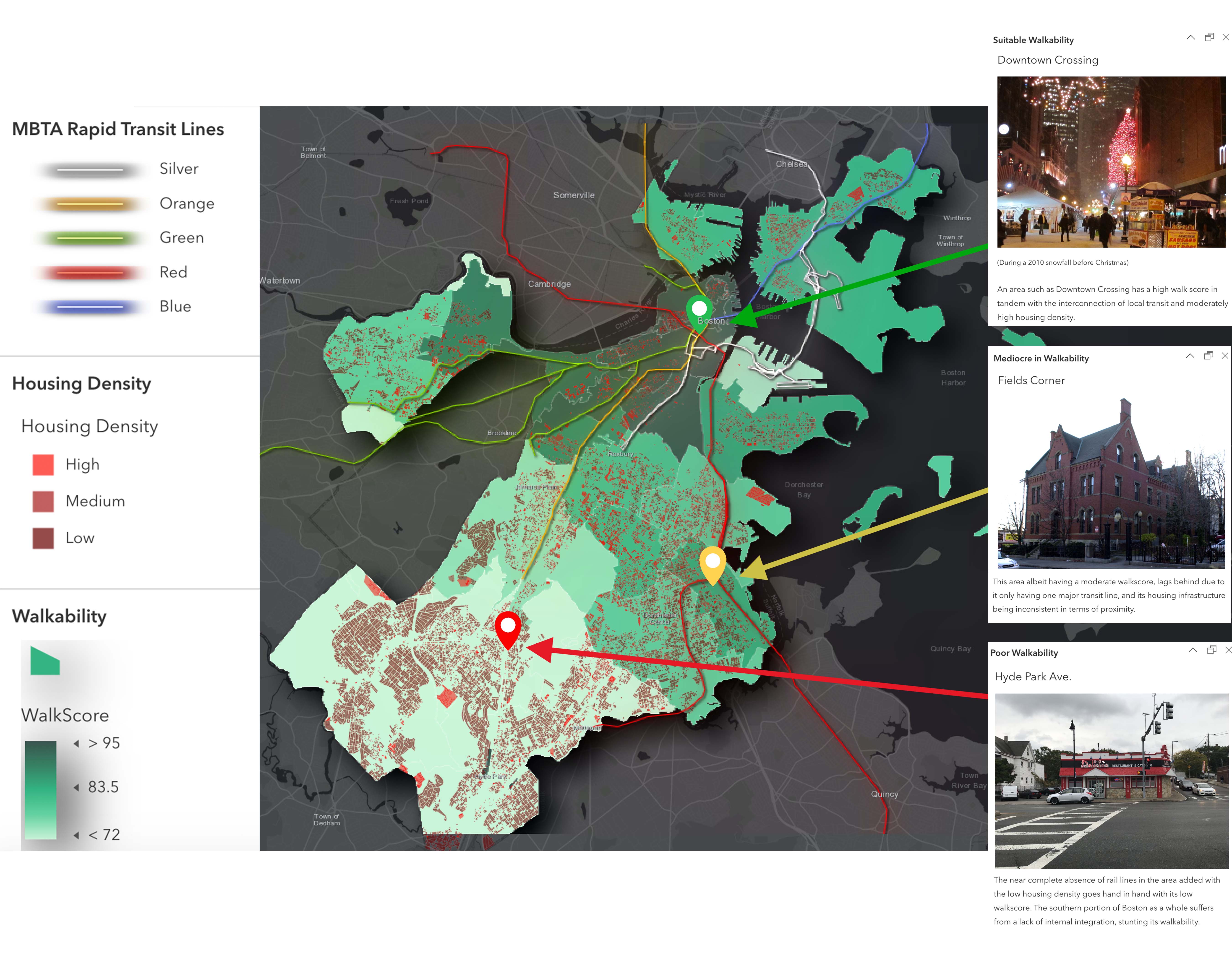
A walkscore is a number assigned to an urban area ranging from 0 to 100 (0 being abysmal and 100 being superb) on how suitable it is for pedestrians. It is based on the amount of walking routes and infrastructural proximity within the area. Typically a higher walkscore signifies environmental sustainability through a lack of car use, greater physical health given increased walking, and generally a high quality of life. On this map, the walk score of different Boston neighborhoods is presented in tandem with some of the city’s infrastructure, represented by transit line and housing density layers. Each separate transit line was colored according to its namesake. Housing density is illustrated with scattered red polygons, with lighter shades representing high density and vice versa. Within the walkability layer, lower and greater walk scores are shown in lighter and darker shades of green respectively.
Digital maps from the ArcGIS and Living Atlas databases were used as the basis of data layers. The data layer MBTA Rapid Transit Lines/MBTA_Rapid_Transit_Lines was chosen to represent the disconnectedness of Boston’s most frequented sources of transit. The tile layer Housing_Density_Boston is shown to emphasize the city’s lack of internal integration, with swaths of housing being fairly separated from any rapid transit. To tie the former layers together, the flat map ZipCodes WalkScore Shapefile attributes a “WalkScore” to each Boston neighborhood. The colors of this layer were changed to contrast higher walk scores with lower ones in a more visually appealing manner. The neighborhoods of Hyde Park Avenue, Fields Corner, and Downtown Crossing are labeled in pop-ups describing their walkscores and infrastructure, with Downtown Crossing having one of the highest walkscores and Hyde Park Avenue having one of the lowest.
This map is to highlight the strengths and weaknesses that come with how the city of Boston is physically, socially, and societally structured. It should lead to its viewers making connections between Boston’s infrastructure and quality of life, as urban livability and environmental sustainability typically correlates with walkability. An interconnected and non-car-dependent city should be a precedent and not an exception in urbanism.

