
February 19, 2024
Transit Challenge Voting Has Begun!
In our most recent Cartography Challenge, we asked mapmakers to dream up other versions of Boston’s transit system. We received 11 amazing maps—but we need your help to decide on a favorite!
The winner of the People’s Choice award will receive a $50 prize. Voting can only be done in person, so come check out the submissions at the Leventhal Center’s gallery and cast your vote for the “People’s Choice” award! Voting will be open until February 23.

An Interview with Julia Williams: Our New Communications & Gallery Coordinator
We’re excited to welcome Julia Williams to the team as our new Communications & Gallery Coordinator! Julia is a researcher and educator with an MA in Museum Education from Tufts University. We sat down with Julia to learn more about her interests and future work at the Center.
Atlascope Stories from Fall 2023 Interns
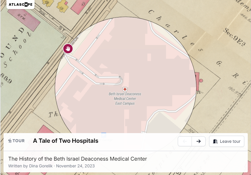
In fall 2023, a cohort of undergraduate students worked on a variety of exciting projects here at the Leventhal Center as Geospatial Research Interns. In addition to their work creating new layers for Atlascope, they set aside time for independent research into topics of their own choosing. Check out their Atlascope tours on The Birth of Boston’s Chinatown: 1870s-1940s, Boston’s Sugar Refineries Amid the American Sugar Trust, and The History of the Beth Israel Deaconess Medical Center
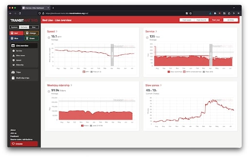
TransitMatters Virtual Webinar: Transportation Advocacy and the Data Dashboard
Join us for a virtual event with TransitMatters on February 21 7-8 pm ET, as they discuss their award-winning Data Dashboard tool, and the impact that open data has had on transportation advocacy nationwide.
Since its founding, TransitMatters has focused on helping Greater Boston advocate for the safe, frequent, and reliable transit. The TransitMatters Labs Team drives transportation advocacy by building tools with MBTA data to engage the public and increase transparency.
The Data Dashboard has played a prominent role in increasing awareness about slow zones throughout the MBTA network. Learn more about how this tool was built and discuss future possibilities for civic data design.
Teachers: Join us for a 2024 Summer Institute - Last Call!
This summer we will welcome 25 educators in grades 3-12 to Portland, Maine, and Boston, Massachusetts, from July 14 to July 26, 2024 for the NEH Summer Institute “Teaching With Maps: Community and Resilience in Maritime New England,” in partnership with the Osher Map Library and Smith Center for Cartographic Education.
During the two-week program, teachers will explore how maps and landscapes reflect, erase, obscure, and celebrate Black and Indigenous geographies and histories along New England’s maritime coast. All participants will receive a $2,200 stipend for completing the NEH Summer Institute. Applications will close on March 5.
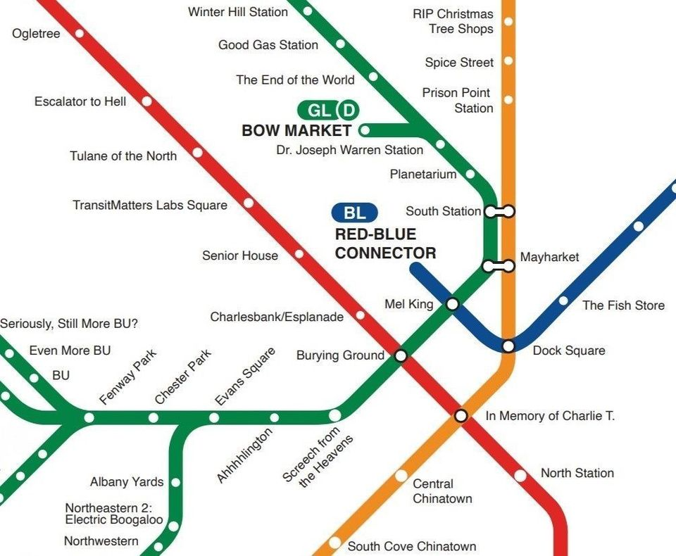
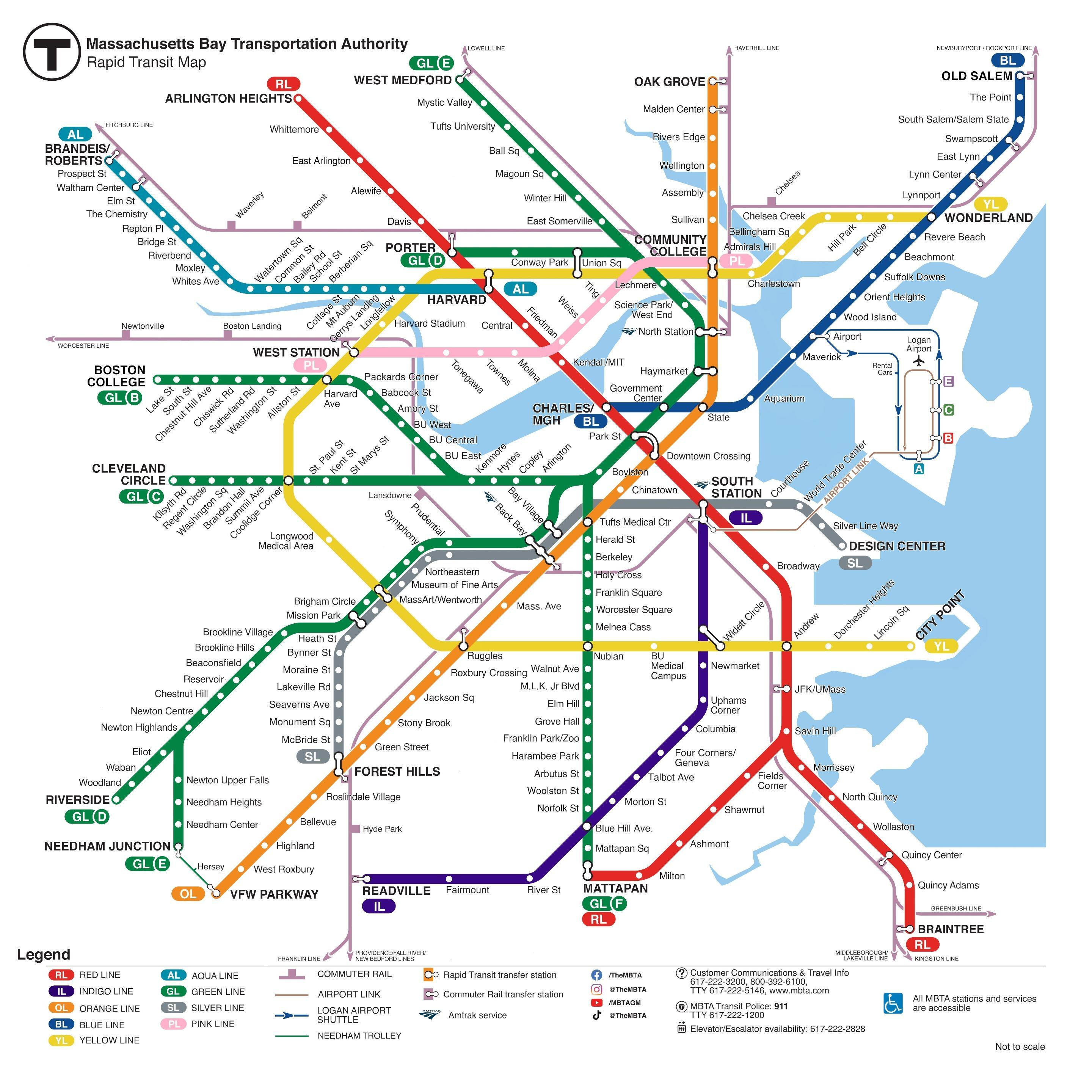
A Re-Named Map of Boston’s Subway Stations: A Social Media Sensation
Throughout the month of November 2023, we asked our supporters to help us out with a creative and collaborative map project: renaming Boston’s subway stations. Donors were able to bid on the “rights” to re-name various stations on the Red, Orange, Green and Blue lines and we think they did a great job of capturing the spirit of each station!
In late January, we released the map to the public and were taken aback by the level of community support. One of our most popular posts to date, Bostonians around the city liked, reposted, and commented all about their favorite new names for the stations (“Tulane of the North” for Harvard Square on the Red Line and “Screech from the Heavens” for Boylston Street were some of the most popular). In the days after releasing the full map, we were visited by news crews from The Boston Globe, 7News, Boston 25 News, and WBZ with many other local stations writing about our map!
We were so delighted to see such an outpouring of community support for the project and would like to thank all of the contributors to the map so much for taking part in such an impactful project.

Featured Visitor Maps from Getting Around Town
If you’ve made an in-person visit to Getting Around Town, you may have seen our invitation to make your own maps of Boston or other parts of the world. We’ve gotten to see how creative and detailed our patrons have been and we’d like to show off some of our staff favorite maps from the exhibition.
A staff member will feature their favorite maps in every newsletter going forward through to the end of the exhibition. Check back on social media or in future newsletters to see if your map made it to our feature!
These featured maps were chosen by Emily Bowe, our Assistant Director:
Map of a new proposed MBTA line - The Aqua Line by Dave
Map of an Alaskan Airlines flight from San Diego, CA to Boston, MA
The Leventhal Map & Education Center is an independent nonprofit. We rely on the contributions of donors like you to support our mission of preserving the past and advancing the future of maps and geography.
View this email in your browser
Leventhal Map & Education Center at the Boston Public Library
617.859.2387 · info@leventhalmap.org
{{SenderInfoLine}}