
January 22, 2024

A behind-the-scenes peek at Heaven and Earth
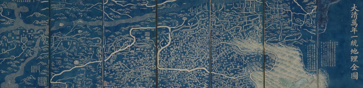
The next exhibition at the Leventhal Center, opening in May 2024, takes a close look at an extraordinary pair of maps from early nineteenth-century China. This exhibition, Heaven and Earth: The Blue Maps of China, will draw viewers into conversations about Chinese material culture, the circulation of printing techniques around the world, and the different perspectives on space and place that emerge from different intellectual traditions. In this interview, we spoke to Dr. Richard Pegg, the guest curator of Heaven and Earth.

In Person: A Conversation with Stacy Thompson & Reggie Ramos · Feb 13, 6:00 pm ET
In our Spring 2024 conversation series Routes Ahead of Us, we’ll take the themes of our current exhibition Getting Around Town and connect the history of Boston’s transit system with questions about how to build a better, more equitable urban mobility system in the future. In the first program, Stacy Thompson, Executive Director of LivableStreets, and Reggie Ramos, Executive Director of Transportation for Massachusetts, will discuss the contemporary social and political contexts shaping transportation policy in Greater Boston. The event will include drinks and refreshments at the Boston Public Library’s Newsfeed Café and tours of Getting Around Town following the conclusion of the program.

In Person: A Conversation with Dan Rosengard on School Transportation · Mar 26, 6:00 pm ET
Later this spring, we’ll also welcome Dan Rosengard, Director of Transportation for Boston Public Schools, to talk about the many ways access to transportation impacts access to education for K-12 students in the city. The event will include drinks and refreshments at the Boston Public Library’s Newsfeed Café and tours of Getting Around Town following the conclusion of the program.

“Boston” versus Boston — what’s the difference?
In case you missed it, Leventhal Center President & Head Curator Garrett Dash Nelson was a guest on the podcast Explain Boston to Me. In the episode, he talks about how the term “Boston” can refer both to the relatively small city proper and a much larger metro area extending deep into New England. The story of these competing Bostons has been shaped by factors like Yankee identity, school snobbery, and local taxation.
Teachers: Join us for a 2024 Summer Institute
In partnership with the Osher Map Library and Smith Center for Cartographic Education, this summer we will welcome 25 educators in grades 3-12 to Portland, Maine, and Boston, Massachusetts, from July 14 to July 26, 2024 for the NEH Summer Institute “Teaching With Maps: Community and Resilience in Maritime New England.” Teachers will explore how maps and landscapes reflect, erase, obscure, and celebrate Black and Indigenous geographies and histories along New England’s maritime coast. Participants receive a $2,200 stipend for participating in the two-week program.
The Leventhal Map & Education Center is an independent nonprofit. We rely on the contributions of donors like you to support our mission of preserving the past and advancing the future of maps and geography.
View this email in your browser
Leventhal Map & Education Center at the Boston Public Library
617.859.2387 · info@leventhalmap.org
{{SenderInfoLine}}