This 1952 photograph covering areas in Boston, Cambridge, and Somerville was taken as part of a series of flights commissioned by William MacConnell. A professor at the University of Massachusetts Amherst, MacConnell worked with his students to photograph forests, wetlands, agricultural land, and other types of land use in western Massachusetts. Eventually, the flights were expanded to cover the entire state and inspired future aerial photography surveys in the 1970s, 80s, and 90s. The photographs taken during these flights served as primary sources for creating maps and geospatial data from aerial photos.
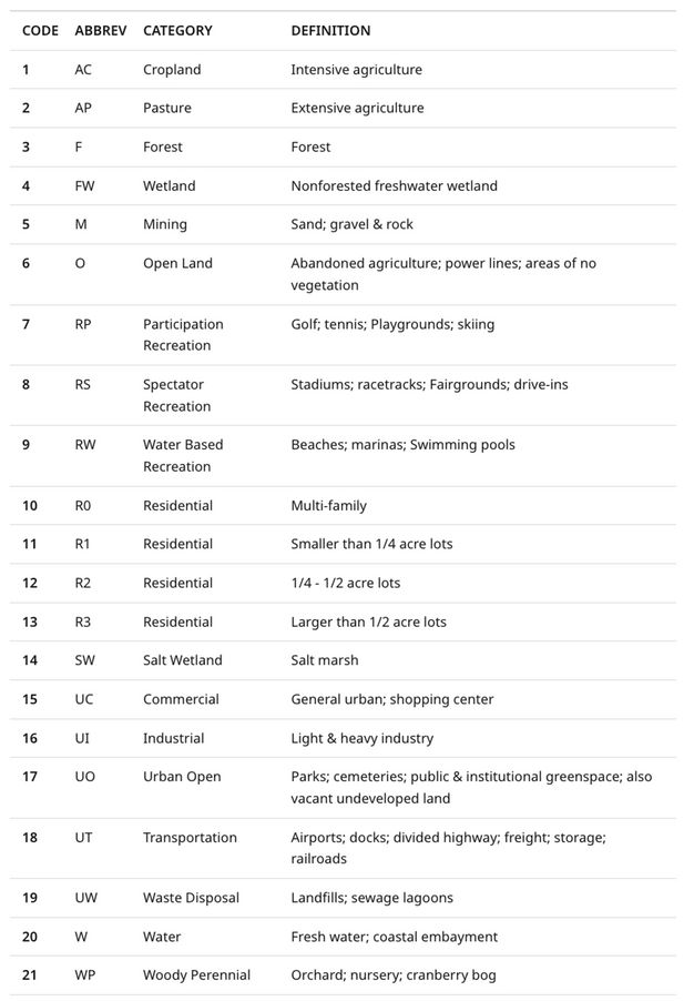
Comparing photographs from the early surveys to later ones reveals how features like land use and transit systems changed over time. In the 1952 photograph, Copley Square—a centrally located, triangular-shaped block—is bordered by a heavy rail yard to the southwest and dense buildings to the south. By 1971, however, a lot has changed: the construction of Interstate 90 (marked “HW”) demolished the buildings south of Copley, while the rail yards transformed into a large shopping center labeled “UC.” In these photographs, hand-drawn annotations mark out areas that correspond to different land uses observed by project researchers. “UC,” for example, refers to a category called “Urban Commercial” and includes structures like shopping malls. You can see more of these land use abbreviations in the table above.