About this object
Part of the methodology and visual presentation of mapping Qing dynasty China was formulated in the mid-sixteenth century during the late Ming dynasty (1368–1644). Luo Hongxian 羅洪先 (1504–64) created the earliest atlas in China, the Enlarged Territorial Atlas (廣與圖 Guangyu tu), which was first printed around 1555. This slightly later edition, dated to 1566, contains 46 maps. The first map, the Complete Terrestrial Map (輿地總圖 Yudi zongtu), became a model for Qing map makers and was the foundation for the Huang family maps. Many of its conventions would eventually be incorporated into the blue terrestrial maps.
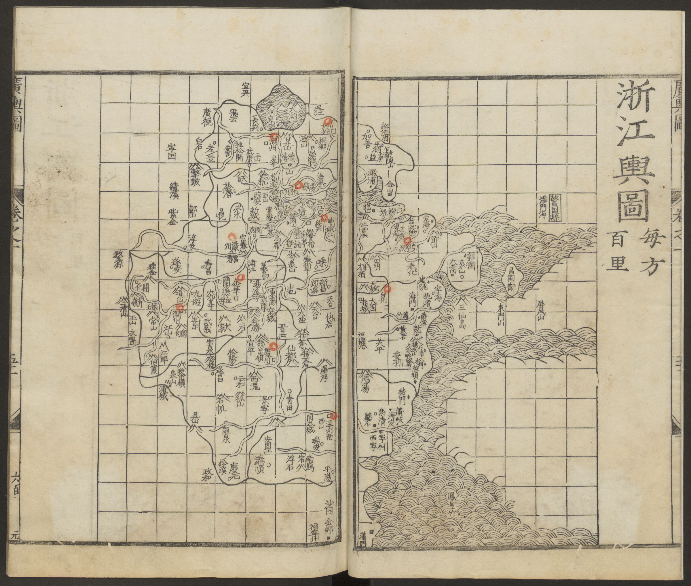
In the Ming and Qing dynasties, administrators were responsible for supplying statistics about their areas of control. That information, in Luo’s atlas, was converted into 24 standardized symbols found in a key, the earliest use of encoded toponyms in China. Instead of encircling the toponyms with a shape, as on the blue maps, the Enlarged Territorial Atlas shows symbols in black next to toponyms. This visual style can be seen in the Map of Zhejiang Province (浙江輿圖 Zhejiang yutu). The atlas visually enabled an easy understanding of administrative and military divisions along with avenues of communication. Encoded toponyms were arrayed on the page in the correct spatial relationships to one another, but not in a precise geographic arrangement. This integration of text and image is a cartographic typology that is unique to East Asian maps.
Catalog essay
Part of the methodology and visual presentation of mapping Qing dynasty (1644-1910) China was formulated in the late Ming dynasty (1368-1644) during the mid-sixteenth century. Luo Hongxian (羅洪先 1504-64) in his well-known Guang yutu 廣與圖 (Expansive terrestrial atlas) created the earliest atlas in China that was first printed in circa 1555.1 This slightly later edition, dated to 1566, has forty-six maps within the atlas, each with a grid called a jili huafeng 計里畫方, its own scale and a descriptive preface. The first map, the Complete terrestrial map (Yudi zongtu), became a model for Qing map makers and was the foundation for the Huang family maps (see essay, entries 3, 6 and 7) and eventually the blue terrestrial map, although it does not include, notably, the great wall.
In the Ming and Qing dynasties, administrators were responsible for supplying statistics about their administrative bodies. Based on census figures, military information and tributary reports Luo Hongxian created his atlas. That information, in Luo’s atlas, was converted into twenty-four standardized symbols that are found in a key, the earliest use of an “encoded toponym.” Luo used different geometric shapes in combination with accompanying text to provide information that included administrative systems, residences and land taxes, garrisons and troop numbers, and roads.
While the grid is absent from the blue maps and only alluded to in the introduction, keying administrative units to specific shapes can be found both on the Guang yutu and the blue maps. Luo Hongxian’s prototype presented the shapes and toponyms differently than on the blue maps: Instead of encircling the toponyms with the shape, the Guang yutu shows the symbols next to the names as can be seen in the Map of Zhejiang Province (Zhejiang yutu, fig.).
The encoded toponyms present the micro-scale Ming or Qing Chinese familial relationships and social structure essential in understanding the macro-scale frameworks of the Ming or Qing Chinese realm and its mapping as valued by the state, presenting the hierarchy visually. The atlas visually presented the tax base and therefore income of the state and enabled an easy understanding of administrative and military divisions along with avenues of communication. The integration of text and image as seen here, where a shape was correlated with a place name that was only generally in a relational location is a cartographic typology that is unique to East Asian maps.2
-
Cao, 1995, 36-7. ↩︎
-
In European-style maps, a place name and any administrative indicator are typically next to each other and separated. The distinction where European cartography tended to polarize subjectivity and objectivity while East Asian cartography united it, is well demonstrated in this map. In addition, scientific and geometric “accuracy” was not an important factor in the making of these maps. And the administrative accuracy is higher than anything achieved in European maps of the period. ↩︎