About this object
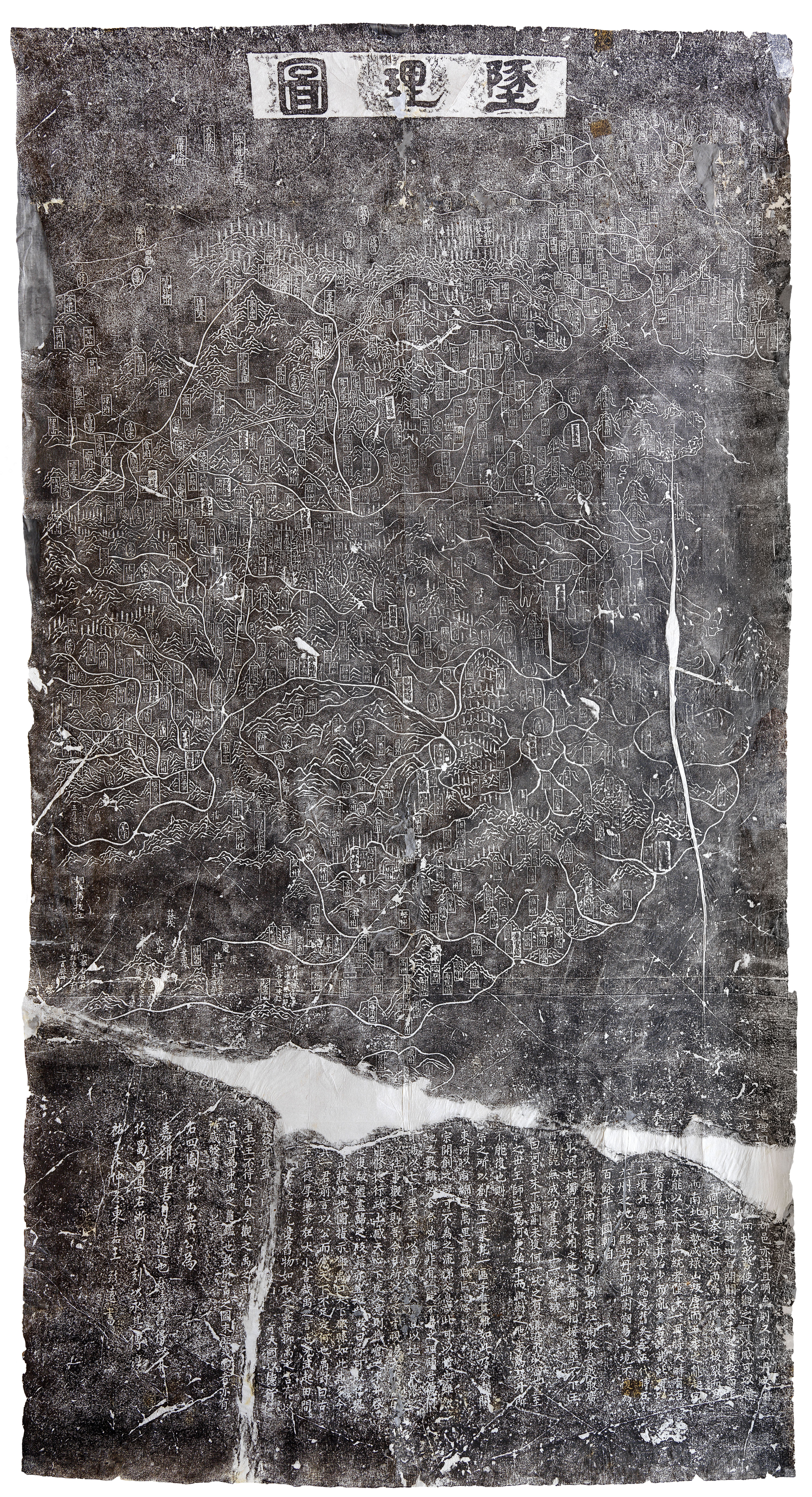
A pair of engravings on stone steles, or vertical slabs, formed the precedents for the blue maps and charts. These steles were first created in the thirteenth century and are still located today in the Confucian temple in the city of Suzhou. The first is a Geographical Map (墬理圖 Dili tu) showing the terrestrial world, and the second is a Celestial Chart (天文圖 Tianwen tu), shown on the next wall.
The scholar Huang Shang 黃裳 (1146–1194), active in the Southern Song court, created both these maps in the 1190s, and subsequently Wang Zhiyuan 王致远 (1193–1257) had them engraved on stone in 1247. Since that time, rubbings on paper have been made as copies of the stone engravings, including the ones on display here.
The Geographical Map on this wall illustrates 368 prefectures, 623 military bases, 73 rivers, 27 lakes, 180 mountains, and 24 passes. It was a deliberate piece of statecraft meant to serve as a moralistic exemplar, setting a model of good government for the young Ningzong emperor, who rose to the throne in 1194.
Catalog essay
The blue maps and charts reference and were inspired by a pair of maps engraved on steles located, then and still today, in the Confucian Temple (Wenmiao 文廟) in the city of Suzhou as confirmed in the epilogue of the 1822 blue celestial chart. One of them is a terrestrial map titled Dili tu 墬理圖 (Geographical map) and the other a celestial chart titled Tianwen tu 天文圖. The scholar Huang Shang 黃裳 (1146–1194), active in the Southern Song (1126–1279) court, created both these maps in the 1190s, and subsequently Wang Zhiyuan 王致远 (1193–1257) had them engraved on stone in 1247 and since that time rubbings on paper have been made of these maps. Huang’s two maps were first meant to be combined to present ideal cosmological models for the young Prince Jia, the future Ningzong 寧宗 Emperor (r. 1194-1224) on good governance. The viewer was meant to visualize that good governance through the correlative properties between heaven and earth found on the micro scale within each of the two maps and on the macro scale in consideration of the entire empire with the two maps combined. Over 600 years after the creation of the steles, Chinese scholars in the city of Suzhou decided to create their own, albeit in blue, updated images of heaven and earth so closely linked to their own city.
The dili tu illustrates 368 prefectures, 623 military bases, 73 rivers, 27 lakes, 180 mountains and 24 passes. The year that Huang Shang presented this map to the court, the Guangzong Emperor (r. 1190-94) abdicated the throne to his younger brother the Ningzong Emperor (r. 1194-1224). The map displays a unified China before the creation of the Southern Song dynasty (1127-1279), a period before the Song imperial family lost north China to the Jurchen-led Jin Dynasty, as an aspiration to a return to the earlier idealized time of the Northern Song dynasty. The dili tu was a deliberate piece of statecraft meant to serve as a moralistic exemplar of the hoped for outcome of good government for the young Ningzong emperor.