This article was written by Salman Uddin. Salman is a student at the Boston Latin School and spent the summer of 2023 as a Seevak Fellow at the Leventhal Center working on public projects related to maps and social justice, and georeferencing atlases for Atlascope.
Academia is one of the defining features of the Greater Boston Area. Higher education institutions draw tens of thousands of students from all over the world who then live in the neighborhoods around these institutions. It takes an array of buildings and facilities to run a functional college or university—buildings and facilities that take up great portions of land. This often means that as the size and prestige of a college grows, the size of the neighborhoods and communities that surround it shrinks. Though not the sole reason, college expansion contributes heavily to the increasing cost of living and decreasing amount of space in neighborhoods. When one driver of a neighborhood’s gentrification is a massive, money-making institution exempt from taxes, it may feel impossible to prevent, but historical examples show what can change when a loud, vocal, and persistent community challenges these forces.
Chinatown
When looking at a map of Chinatown, its history of being meddled with can be visualized. The two biggest changes made to the neighborhood were the Central Artery, a highway through Chinatown built in the 1950s that took the place of over 50 housing structures, and the Massachusetts Turnpike Extension, built shortly after the Central Artery had been built, destroying around 60 housing structures in Chinatown. The two highways were built for the benefit of residents of Boston’s surrounding suburban neighborhoods, but at the expense of the populous urban neighborhood they cut through.
Then, in the 1970s, Tufts New England Medical Center (T-NEMC) began to buy more land in Chinatown with the help of the Boston Redevelopment Authority (BRA). The hospital nearly tripled in size that decade. T-NEMC used its space to build tall multi-story buildings and dense parking complexes, but its parking lots and medical services were not heavily used by actual Chinatown residents, benefitting its doctors and practicing students more than the surrounding community.

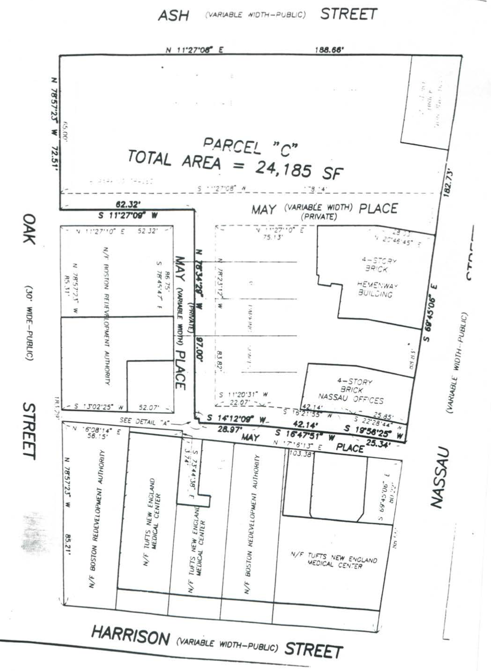
Parcel maps of Boston’s Chinatown and the surrounding area (ca. 1991), Chinese Progressive Association Records. Courtesy of Northeastern University Archives and Special Collections
Parcel C is a 25,000 square foot parcel of land which was cleared by the BRA in the 1960s as part of an urban renewal project and was then left empty for several decades. In the mid 1980s, T-NEMC attempted to purchase Parcel C from the BRA in order to create a multi-story parking garage. The first proposal to build an 850-car garage was rejected by the BRA. In 1990, a proposal to use the entire parcel for residential and community purposes was created and agreed upon by both T-NEMC and the Chinatown community. The BRA accepted the proposal and zoned the area accordingly. Just a few years later, T-NEMC offered the BRA $2 million in order to use most of the space for a parking garage and either build a community center with the rest of the space or simply give $1.8 million to the Chinatown Neighborhood Council (CNC). The BRA accepted this new proposal, contradicting its earlier decision.
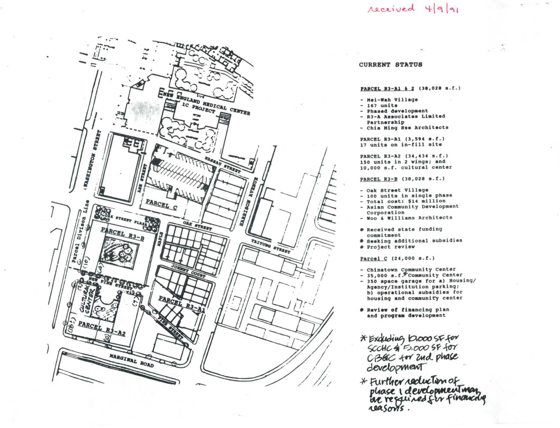
Residents of the community were vocal in their disapproval, but the CNC approved. Even after having been misrepresented by the CNC, members of the community continued to fight for the parcel of land. 2,500 people signed a petition against T-NEMC’s plans, calling themselves the “Coalition to Protect Parcel-C for Chinatown". Committees were created by the Coalition with specific missions and goals. Awareness was raised, moves were made, and, after a long persistent struggle, the parking garage plans were canceled. Parcel C is now home to various community centers and organizations and nearly half of its space is used for affordable housing, detailed on the map below.

Parcel maps of Boston’s Chinatown and the surrounding area (ca. 1991), Chinese Progressive Association Records. Courtesy of Northeastern University Archives and Special Collections
Cambridge
Cambridge’s identity is in many ways defined by the colleges that make their home there. As of 2022, Harvard University owns a little over 200 acres of land in Cambridge, about 190 of which are tax-exempt. Campus expansion really began in the nineteenth century, when 64 acres of land were purchased north of Harvard’s “Old Yard.” Expansion continued in the centuries that followed, with Harvard building dormitories south of the main campus along the Charles River and establishing its presence in Allston. Pushback against Harvard’s growth became more pronounced in the twentieth century. The earliest instances of pushback were from city councilors, but community pushback was also growing. Harvard’s expansion was becoming a threat to the nearby communities that had their own histories separate from the University.

Further east along the Charles River above Western Ave, Harvard purchased a few parcels of land without making any changes. Sitting on land without doing any demolition or renovation was not an uncommon strategy for Harvard and other universities–often waiting until more land could be bought before begining work on new buildings.
Riverside is one such neighborhood. Also known as “The Port” or “The Coast,” its identity is defined by its Caribbean immigrant roots more than its proximity to Harvard. The Port has always had a strong community that could organize and get things done. The building of Harvard’s Dunster House in 1930 saw the University beginning to spread its campus into Riverside.
In the mid-1960s, Harvard had plans to create two multi-story student-housing units in Riverside right next to the Charles River. As a result, residents of The Port were getting evicted at a higher rate because landlords were hoping to sell to Harvard. The need for community pushback was growing.
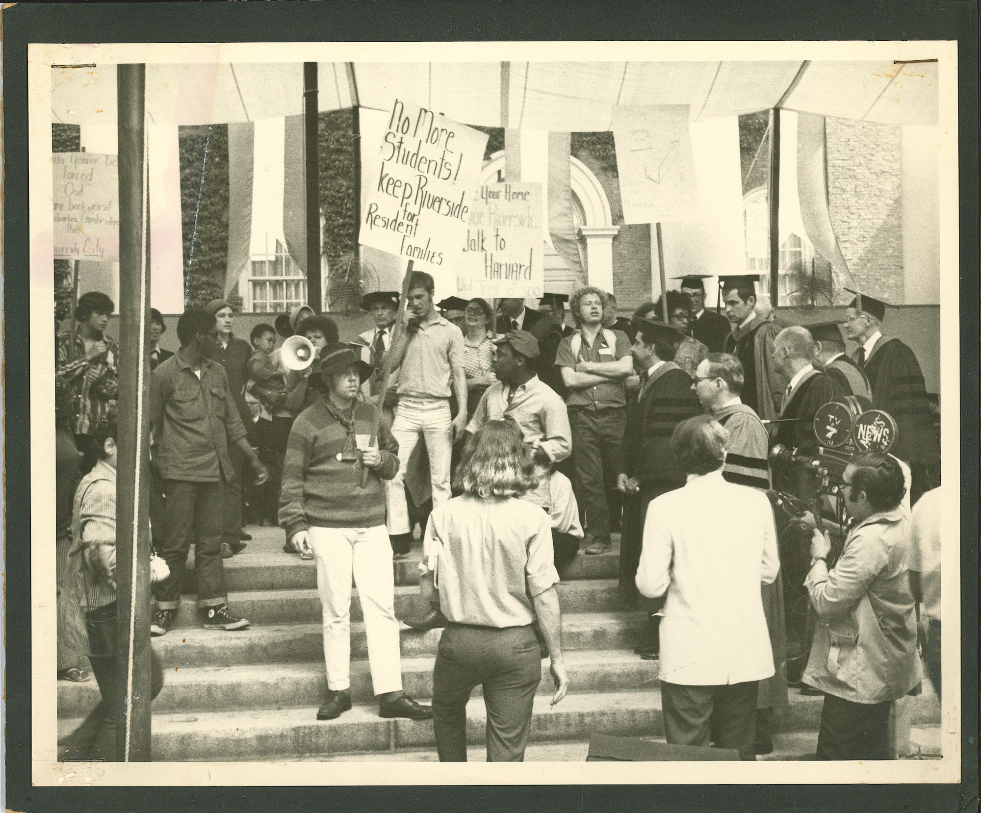
An activist group known as the Riverside Planning Team, led by Saundra Graham, formed with the mission of preserving the community. The team wished to meet with the Harvard Corporation about their concerns, but no member of the Corporation was willing. It wasn’t until the team organized a march on Harvard’s commencement in 1970 that their demands were heard. A meeting was finally organized. Harvard was still adamant about continuing their plan and no satisfactory compromise was made. The community continued to pressure the University despite this, and eventually Harvard agreed to use some of the land for affordable community housing.

Courtesy of Harvard University Archives, HUM 322 Box 3, Folder 15
Roxbury
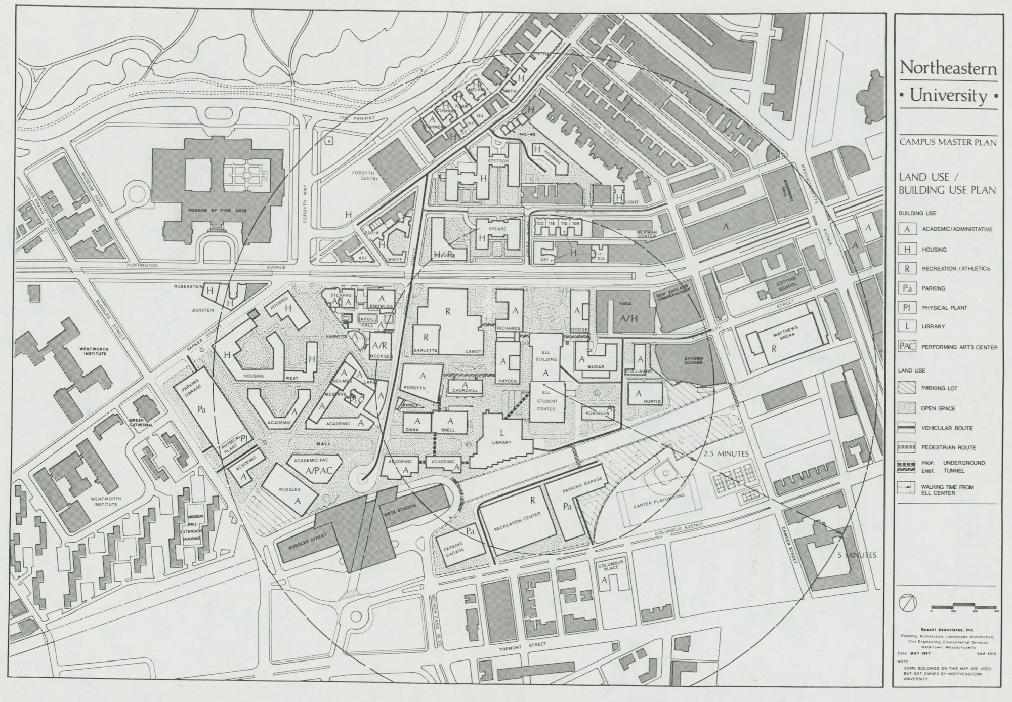
Institutional expansion is an ongoing threat to the communities in Roxbury. In the past few decades, Northeastern University has been growing in size, prestige, and enrollment. The university’s annual student population has increased by around 8,000 students in the past ten years. Originally a commuter school, Northeastern began building its first dormitories in the 1950s.

Northeastern University Office of Physical Planning and Design Records. Courtesy of Northeastern University Archives and Special Collections
It was around this time that Northeastern’s Office of Development and Planning decided that it wanted to become a bigger, more influential school. Part of the reasoning for this was they felt the need to push and grow their Cooperative Work Program. It was also driven by the desire to become as prestigious as the schools nearby, like Harvard and MIT. As stated in Northeastern’s 1959 Campus Master Plan,
Northeastern University, by sheer mass and size, is a major entity within the urban neighborhood. However, the campus lacks the symbolic or special presence typically associated with major universities.
Today, Northeastern University has in many ways become the type of university it sought to become. In 2013, Northeastern implemented its 10-year plan which involved 3 million square feet in construction projects. The 2010s have been a decade of rapid growth for the University and that rate of growth is likely to continue; Northeastern’s most recent plan is an 810-bed dorm on Columbus Ave. In 2021, Northeastern University housed 49.5% of its over 20,000 students.
On top of taking up land in its expansion, the university puts pressure on Roxbury’s rental market with its unhoused students. The need for Roxbury residents to push against the university’s expansion is only growing. Reclaim Roxbury is one of the foremost organizations fighting gentrification and displacement in Roxbury. It began in 2015 to fight against the BRA’s plans to develop what was “publicly owned land” and seeks to broadly protect Roxbury residents’ quality of life and economic wealth. Northeastern University is a growing concern for the organization and it will likely continue to be one in Roxbury’s future.
Our articles are always free
You’ll never hit a paywall or be asked to subscribe to read our free articles. No matter who you are, our articles are free to read—in class, at home, on the train, or wherever you like. In fact, you can even reuse them under a Creative Commons CC BY-ND 2.0 license.