On June 21, we hosted From The Vault: Views of Housing & Home.
From The Vault is a biweekly event series showing collections objects selected by Leventhal Center staff with this week’s theme specially curated by our Assistant Curator of Digital & Participatory Geography, Ian Spangler! In this From The Vault, we asked what do “housing and home” mean to you? Whether they’re are viewed as economic commodities, cultural signifiers, or basic rights will differ drastically depending on whom you ask. When depicted in maps, these different perspectives can alter our perception of what housing and home mean. During the event, we explored these different perspectives and asked questions about why our understanding of home can look so different for so many people.
Ignatz Sahula 19th annual convention of the National Association of Real Estate Boards : at Tulsa, June 7 to June 11 in 1926 (1926)
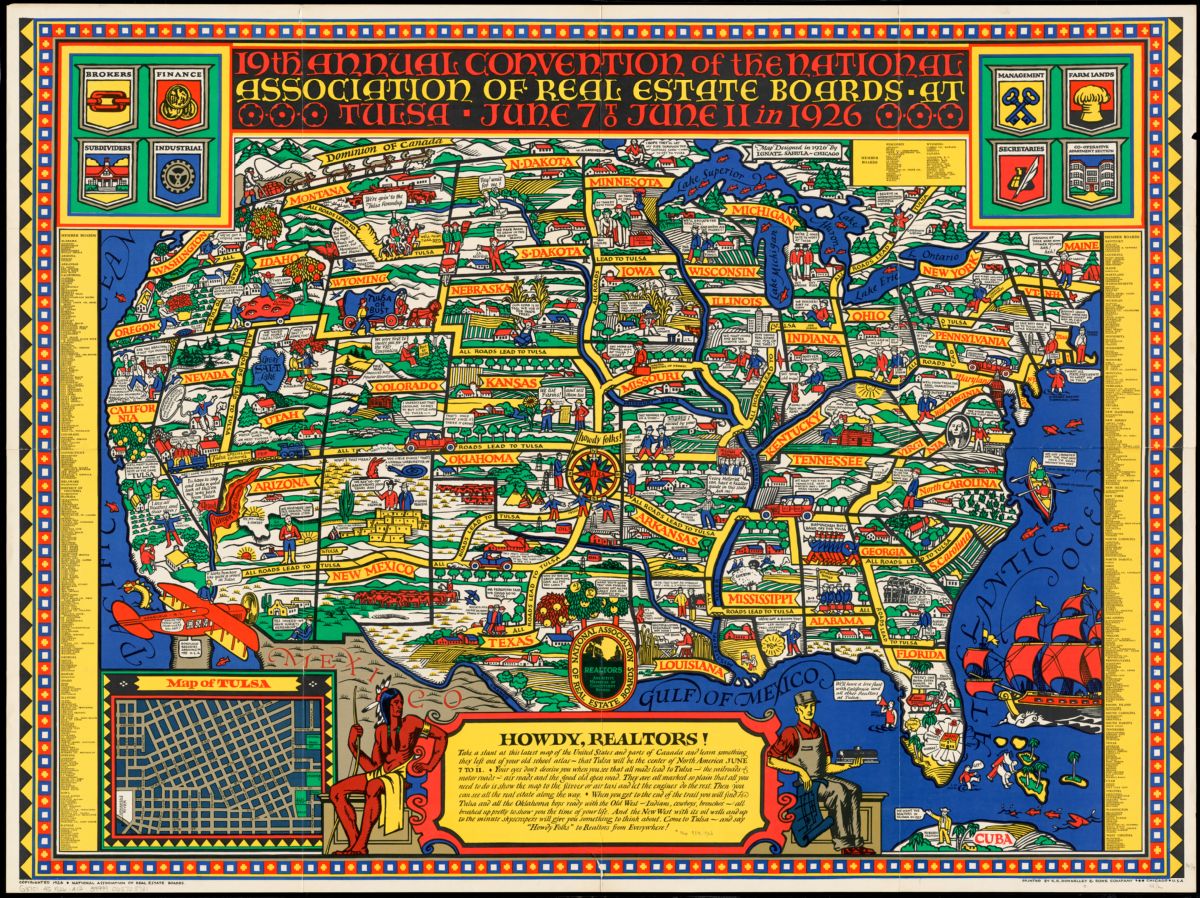
The National Association of Real Estate Boards (known today as the National Association of Realtors®) created this map in 1926 to promote the realtors’ 19th annual convention. In playful and sometimes shocking detail, it highlights the kinds of professional activities and behaviors that informed realtors’ cultural, economic, and professional identities at the time. In Miami, for example, we find L.W. Crow kicking the curbstone “binder boys” into the sea, while just north of Ontario, Goodwin Gibson professes his belief in “international multiple listing.” At the same time, the map showcases common prejudices held by the real estate industry, visible in the racist depiction of a Black man in Mississippi – a reminder of the historical exclusions and discriminatory practices that have haunted U.S. housing for hundreds of years.
H. T. Whitman Plan of Orient Heights, Boston, Mass (1894)
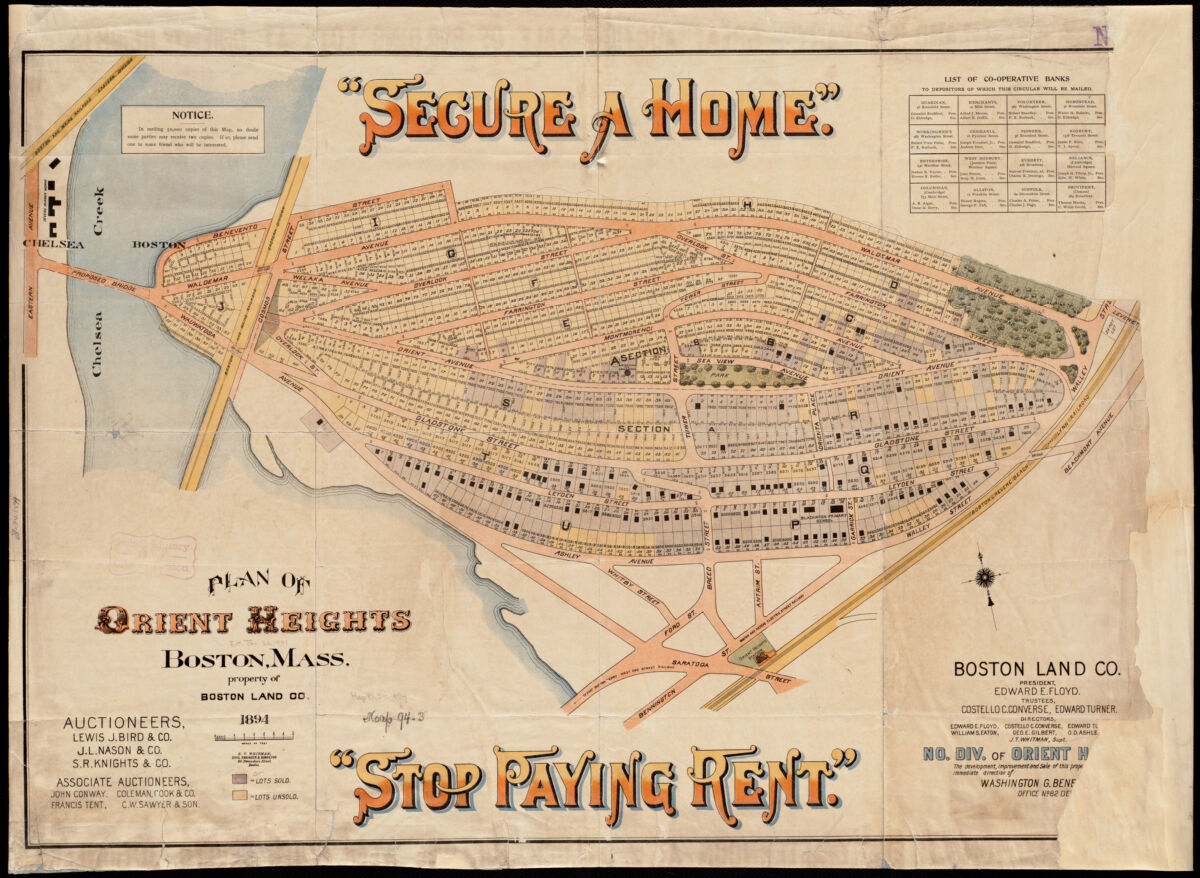
With Boston’s rising population and increased demand for housing, the Boston Land Company began to develop former marshland in East Boston in the 1880s, including Hog Island (also called Breed’s Island) which became Orient Heights. This promotional map invites the viewer to imagine themselves in one such newly developed suburb. The invocation to “SECURE A HOME” and “STOP PAYING RENT” may seem like a simple advertisement, but it also serves as a precursor to the “Own Your Own Home” movement that would take off a couple of decades after this map was made. Homeownership would become associated with responsible citizenship, and so-called “transient” renters were considered unscrupulous.
Boston Redevelopment Authority Three-decker Housing in the City of Boston: a Reconnaissance (1974)
Boston Redevelopment Authority Boston’s Triple-deckers (1978)
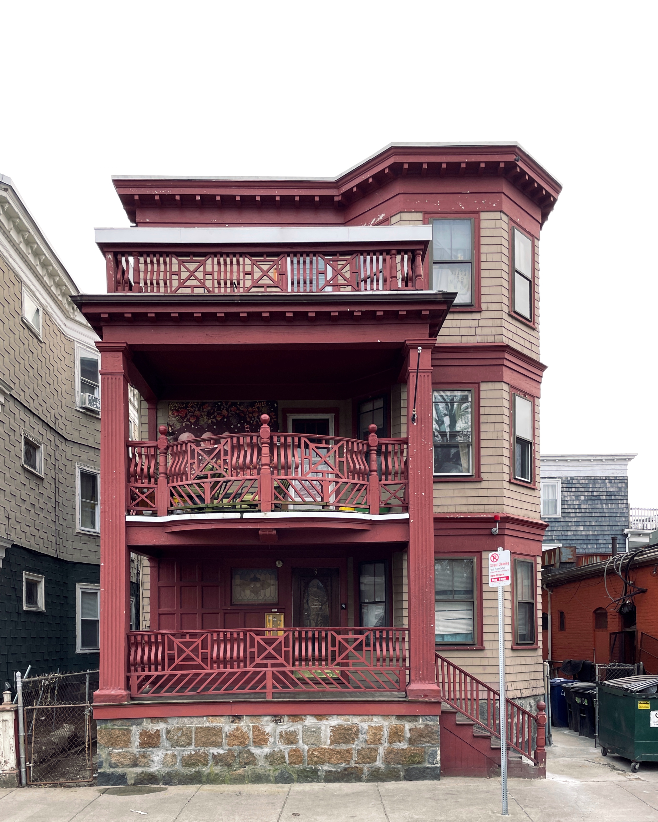
Example of a Boston triple-decker home
A city’s shared history depends greatly upon its unique architectural styles. In the Greater Boston area, there is perhaps no style more quintessential than the so-called “triple-decker.” In the 1870s, these three-story buildings enjoyed a surge in popularity. By 1920, about 15,000 triple deckers had been constructed. Created by the Boston Redevelopment Authority (BRA) in the 1970s, these maps document the distribution of triple decker homes in the City of Boston.
W. E. B. Du Bois The Seventh Ward of Philadelphia : the distribution of Negro inhabitants throughout the ward, and their social conditions (1899)
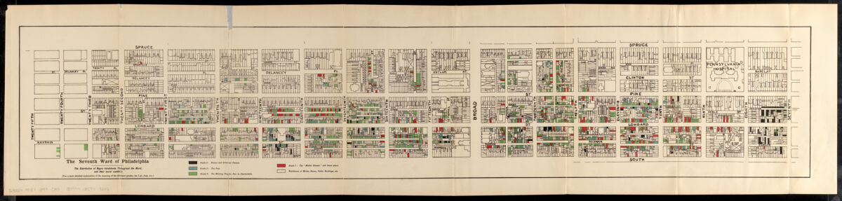
By the end of the 19th century, Philadelphia was home to 40,000 African Americans, comprising the largest population in any northern city. Drawing from the sociological studies by residents of Chicago’s Hull House, African American sociologist W. E. B. Du Bois undertook a similar study in Philadelphia, focusing on Ward 7, the location of the city’s oldest Black neighborhood. In this community with roughly 9,700 residents, Du Bois and his associates conducted approximately 5,000 interviews. Their findings were published as The Philadelphia Negro (1899), which included this fold-out map with the location of every residence, church, and business owned by Black people.
Gideon Hawley Plan of Mashpee (1785)
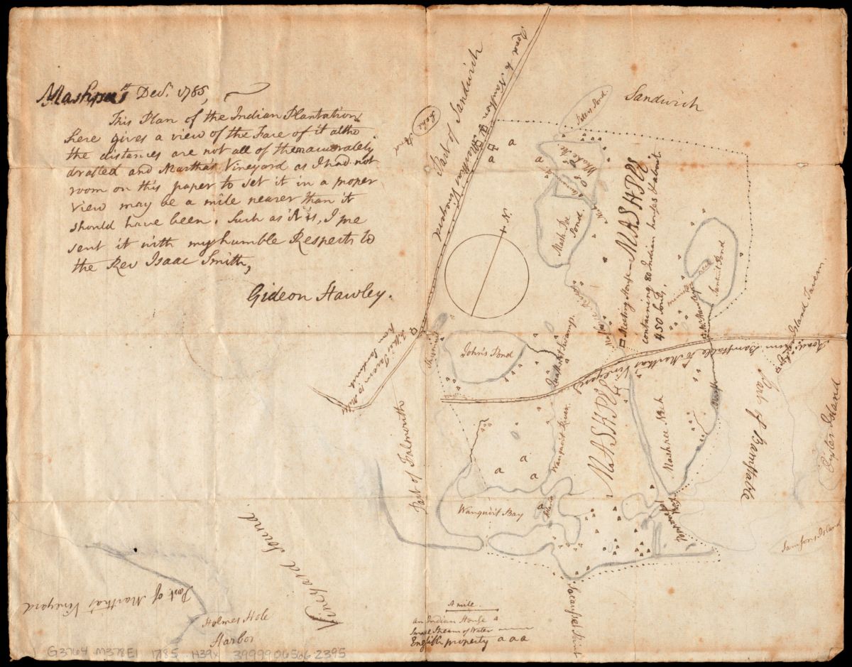
This manuscript survey sketch provides an early example of the treaties between American leaders and native peoples that designated land for their use. Gideon Hawley, a Christian missionary to the Mashpee Indians, drew this reservation map for Reverend Isaac Smith. Like most Native American tribes in Massachusetts, the Mashpee lived on Cape Cod. The Mashpee fought with the Americans during the Revolutionary War and suffered heavy losses. In 1783, Hawley noted that there were at least 70 widows on the Mashpee reservation, most of whom had lost their husbands during the war.
Boston Redevelopment Authority South End urban renewal area R-56 : re-use parcels (1965)
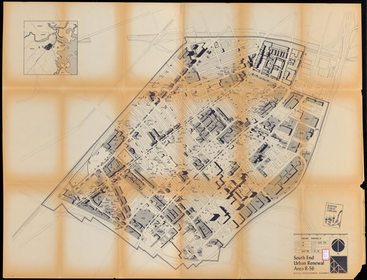
During the 1960s and 1970s, the Boston Redevelopment Authority (BRA) produced hundreds of maps that depicted “urban renewal areas” across the city of Boston. These areas had been identified as targets for reinvestment of federal funds as part of the Housing Act of 1949, which set aside funds for “slum clearance.” This map depicts the BRA’s proposal for urban renewal of various parcels in the South End, including Parcel 19 (listed “P19” on the map). In the late 1960s, the largely Puerto Rican residents of Parcel 19 founded Inquilinos Boricuas en Acción (IBA) in order to prevent displacement from their homes.
The following photos and materials document some of the tenant movements in the Boston’s South End and Chinatown, including Inquilinos Boricuas en Acción (IBA), which founded Villa Victoria in the South End, and the tenants of 90 Warrenton Street who fought against evictions in Chinatown. Especially in the 1960s and 1970s, tenants across Boston who were fed up with high prices, poor conditions, and the prospect of displacement began to organize with one another for better housing conditions.
Our articles are always free
You’ll never hit a paywall or be asked to subscribe to read our free articles. No matter who you are, our articles are free to read—in class, at home, on the train, or wherever you like. In fact, you can even reuse them under a Creative Commons CC BY-ND 2.0 license.