On July 5, we hosted From The Vault: Revolution and Independence!\
From The Vault is a biweekly event series showing collections objects selected by Leventhal Center staff. In this From The Vault, as we enter the 250th year since America’s first fight to gain independence, we had an opportunity to reflect on our nation’s founding and on similar historic events of the past. We were able to examine maps that showcased the peoples, regions, and nations that worked to revolutionize their social structure and gain independence from those that sought to suppress their freedom. With over 130 visitors over the course of the two hour event, this was our most successful From The Vault event yet!
Jacques Nicolas Bellin La partie Francoise de l'isle de Saint Domingue (1764)

The Haitian Revolution has often been described as the largest and most successful slave rebellion in the Western Hemisphere. Enslaved people initiated the rebellion in 1791 and by 1803 they had succeeded in ending not just slavery but French control over the colony. In the 18th century, Saint Domingue, as Haiti was then known, had become France’s wealthiest overseas colony and generated more revenue for France than all 13 North American colonies for Britain. All of this money was made through agricultural trade through the work of over 500,00 enslaved people, outnumbering White people and freed colored people 10 to 1.
Led by former slave Toussaint l’Overturein 1791, L’Overture was eventually captured and sent to France where he died in prison in 1803. Jean-Jacques Dessalines, formerly enslaved and one of l’Overture’s generals, led the revolutionaries at the Battle of Vertieres on November 18, 1803 where the French forces were defeated. On January 1, 1804, Dessalines declared the nation independent and renamed it Haiti.
Pichon Nouveau plan routier de la ville et faubourgs de Paris avec ses principaux édifices et nouvelles barrières (1802)

The French Revolution was an event that had worldwide impact and gave many the courage to fight back against oppressive ruling governments. Began in 1789 and ended in the late 1790s with the ascent of Napoleon Bonaparte, French citizens radically altered their political structure. The upheaval was caused by disgust with the French aristocracy and the economic policies of King Louis XVI who had left France incredibly economically unstable. Revolting against years of exploitation, peasants looted and burned the homes of tax collectors, landlords and the aristocratic elite.
This map was created post-war and highlights the important cultural features of the city and showcases the deliberate planning, organization, and expansion of Paris. Depicting the rebuilding of Paris after the French Revolution, you can see the expansion of the city past its old city walls symbolizing a healing and growing nation.
Samuel Swett Sketch of Bunker Hill Battle (1826)
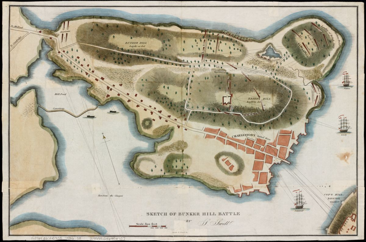
This map depicts the Battle of Bunker Hill, known as the first major battle of the American Revolution. The battle took place in Charlestown, just outside of Boston, and was named after the tallest hill in the area, though the majority of the battle took place on Breed’s Hill, located near the center of the map. Lines of fire, British entry points, and a colonist fort are depicted on this map created 50 years after the initial battle.
Robert Sayer and John Bennett The theatre of war in North America, with the roads and a table of the distances (1776)

A full and in-depth account of all of the British colonies and their populations in North America. Included with this detailed map are full descriptions of each region, including regional markers, prominent counties and the towns within them, all large lakes, rivers, capes, and bays. Also featured on the center-right of the map is a chart showing how the distance (in British miles) between prominent colonial cities were from each other. A map of this kind would have been incredibly helpful to orient the British military to the new American fight for independence.
Mondhare Reddition de l'armée Angloises commandée par Mylord Comte de Cornwallis aux armees combinées des Etats Unis de l'Amerique et de France aux ordres des Generaux Washington et de Rochambeau a Yorck Touwn et Glocester dans la Virginie : le 19 Octobre 1781 (1781)
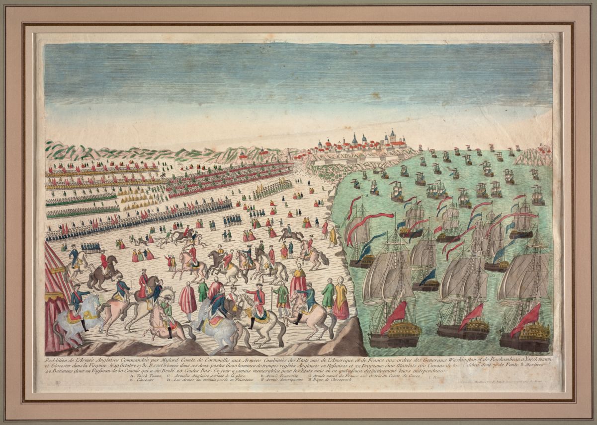
A unique Revolutionary-era map, this depicts a French perspective of the British surrender at Yorktown to the Americans. After six years of war, both the British and American armies were exhausted and ready for an end to the war. In 1781, Washington and his French ally, Lt. Gen. Comte de Rochambeau decided to attack Yorktown, Virginia where a large amount of British troops were stationed. Making the hundreds of miles trek in the largest troop movement of the war, the American and French forces were met with a French fleet and surprised the British troops with a siege. This was the last major land battle of the American Revolution and led to negotiations for peace with the British and the signing of the Treaty of Paris in 1783.
E.A. Aston Carsonia the great betrayal! (1920)
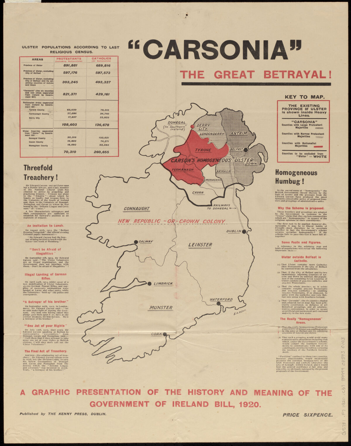
From the middle of the Irish independence war, this map focuses on the division of Ireland and makes a case for why the argument to splitting up Northern Ireland along religious lines wasn’t being correctly considered. Sir Edward Carson, a prominent political figure from Dublin, claimed that the proposed Northern counties were religiously homogeneous and Protestant (who supported Britain).
While technically true, the religious divide was much closer to an equal 50/50 split of Protestants and Catholics (who supported a totally free Irish state). This caused many to call Carson a traitor and betrayer by using deceiving tactics to force the nationalist Catholics into a heavily policed and discriminatory North Ireland. The Republic of Ireland was formed in 1922 as a free state, while North Ireland remains a part of Britain to the present.
Charles Magnus & Co Magnus' panoramic view map of India (1857)

Created in the midst of India’s first War of Independence (also known as the Sepoy Mutiny) this map indicates the “Leading Seats of Insurrection” against the British in a bright, nearly blood red color. Though unrest had long been stirring during the British occupation of India, it wasn’t until 1857 that the first fight for independence began.
The breaking point came when Indian soldiers, called sepoys, were given bullets by British officials that in order to be used required their casings to be bitten off. These bullets were greased with lard, believed by Indian troops to be either pig or cow fat. The use of cow fat goes against doctrines of Hinduism, while the use of pig fat opposes Islamic doctrine, the two major religions of India. The insult to both religions sparked rebellions by Indian sepoys against their British officers.
Our articles are always free
You’ll never hit a paywall or be asked to subscribe to read our free articles. No matter who you are, our articles are free to read—in class, at home, on the train, or wherever you like. In fact, you can even reuse them under a Creative Commons CC BY-ND 2.0 license.