On January 10, we hosted From The Vault: New Acquisitions.
Calling all cartography enthusiasts! Prepare to see some of the newest acquisitions to our collection of over 250,000 maps, atlases, globes, and other cartographic objects. Some chosen for their visual impact, others for their depictions of space and place, and even more for their interpretation of history and relevant information, these maps are sure to educate and impress.
Paul Koroleff, Carte touristique du Liban kharitat Lubnan almusawarat lilsiyaha (1955)

A 1955 tourist map of Lebanon, this map acted as a type of advertisement to visit and see the sights. On the bottom right hand side of the map, a number of cities and towns are listed alongside different attractions like resorts, cafes, and historical sites. Most of the text is in Arabic with some English translations, signifying the multicultural audience this brochure is intended for. In addition to the dual language use, the pictorial nature of the map also appeals to those who aren’t able to speak Arabic, ensuring that the map can still be understood with limited language use.
Frederic Milton Thrasher, Chicago's gangland (1927)

Showing gangs with clubrooms, those without, and indicating private and public property, this map was meant to be an all-encompassing view of the gangs present in Chicago. Completed as a part of a larger study, the map also lists the names of certain regions and previous illegal activity or attacks that occurred around the area. Something to note is that this map also outlines areas with prevalent ethnic groups, including “Americans” as a broad term for multi-generational White Americans.
Boris Artzybasheff, World map of the major tropical diseases (1944)

This map shows the locations of diseases around the world using text, illustrations and color to grab the viewer’s attention. Included at the foot of the map is a description of each disease, how it’s typically contracted, and how it’s most often treated. 15 diseases are represented here, including malaria, yellow fever, dengue, typhus, plague, cholera, sleeping sickness, tularemia, Rocky Mountain fever, Japanese river fever, relapsing fever, helminthic diseases, yaws, leprosy, and leishmaniasis.
Created for LIFE Magazine in 1944, this map would have been highly accessible to the public. This is especially important given the time frame of Americans entering the army and beginning to fight abroad in World War 2.
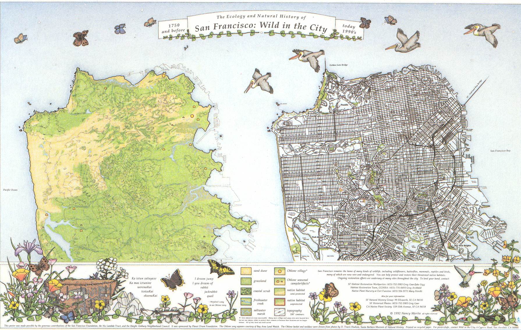
Nancy Morita, The ecology and natural history of San Francisco wild in the city (1992)

This poster-style map compares a view of the natural geography of San Francisco before colonization (1750) with a then present-day (1990s) street map to show what features could be restored to their natural state. The natural side of the map shows the location of the sand dunes, grasslands, wildflower-butterfly hilltops, Ohlone village sites, creek paths, salt marshes, and berry-brushlands that “underlie” the city of San Francisco.
This map was created, in part, to reintroduce the natural landscape to San Franciscans and help them understand how it continued to influence their lives in the urbanized city 200+ years later. One example is to help explain why some people’s basements flood or buildings sink. This map was also attempting to help city dwellers connect more with urban wildlife and strengthen their connection with local wild areas’ restoration efforts.
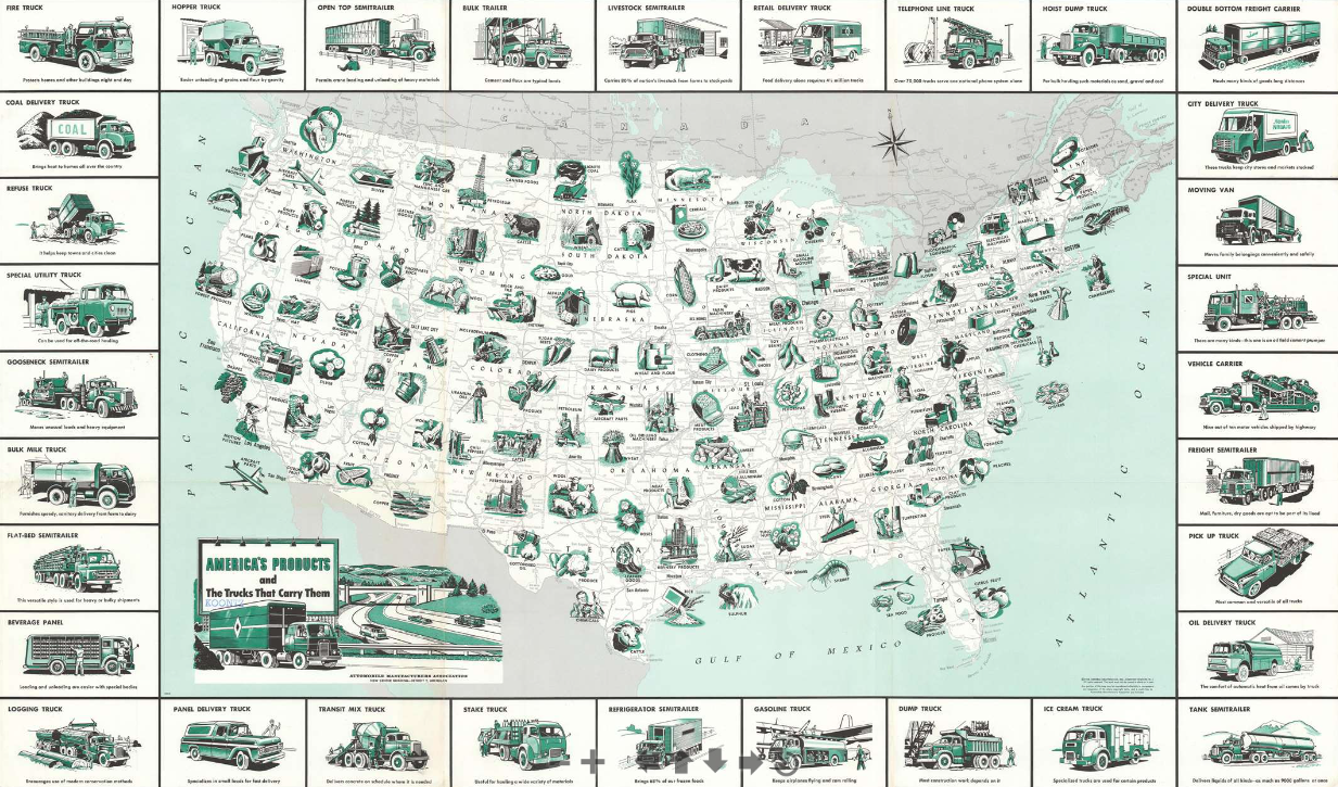
General Drafting Company, America's products and the trucks that carry them (1958)

This is a 1958 General Drafting Company pictorial map of the United States, its industry, and the transportation network used to move its products. The map follows the 1956 Federal-Aid Highway Act, celebrating the success of the American Highway system and the hard work of truckers in moving goods along a growing network of interstate trade.
Pictorial vignettes highlight American production, from agricultural goods to aircraft parts and automobiles. Corn, potatoes, walnuts, citrus fruit, and flour appear among the nation's agricultural products. Coal, lead, uranium ore, copper, aluminum, and phosphates are named among the nation's mineral resources. Farm machinery, shoes, synthetic rubber, textiles, and paper represent a handful of manufactured products. America's highway network, illustrated below the green vignettes in shades of gray, serves as a network of commerce. The trucks that create the map's border carry it all, with many still in use today. Many of these were designed with specific purposes in mind: logging, beverage panel trucks, telephone line trucks, bulk milk trucks, ice cream trucks, and vehicle carriers, etc.
Walker Lith., Canobie Lake Park, Salem N.H. (1912)

Canobie Lake Park is a staple of New England summers. Now known for their roller coasters and Taylor Swift impersonator, the park was originally a “trolley park” located at the end of the Massachusetts Northeast Street Railway Company and was designed to encourage trolley use on the weekends. To that end, this map was initially designed as a foldable brochure. At the time of this map’s creation in 1912, Canobie Lake Park consisted of flower gardens, walking paths, and “gentle attractions” like a swimming pool.
Panoramic view of Boston centered on the Prudential Tower (1968)

This map from 1968 shows a bird’s eye view of what the Prudential Tower and its surroundings looked like when it was first completed—spot the separate buildings that make up the tower in the middle (the compass rose marks the top of the tower).
When first built in the early 1960s, the shopping centre we know now was a part of a huge redevelopment wave in Boston (think Boston City Hall, Government Center, etc). It was originally a series of separated buildings with the main “Prudential Tower” as the centerpiece. Over the years, the buildings were connected, bridged, and developed into “the Pru” we know today that welcomes more than 60,000 visitors a day.
Our articles are always free
You’ll never hit a paywall or be asked to subscribe to read our free articles. No matter who you are, our articles are free to read—in class, at home, on the train, or wherever you like. In fact, you can even reuse them under a Creative Commons CC BY-ND 2.0 license.