On July 19, we hosted From The Vault: Functional Advertisements
From The Vault is a biweekly event series showing collections objects selected by Leventhal Center staff. In this From The Vault, the spotlight was on maps as functional advertisements, which can be defined as a marketing strategy for companies or institutions to included a useful and functional item in their ads as an added benefit to draw in consumers. As you read along, consider how these maps act as historical artifacts and imagine what life was like for the average consumer of the early 20th century, the maps' target audience.
Don Bloodgood Ask Shell! (1948–1955)

This corporation decided to take a unique approach to incorporating maps into its ads. A map created for Shell—the oil company—is shown above. This map is one of the more modern in this collection, as we can see because of its use of automobiles. The company used this abstract land to sell its customers the idea of a perfect vacation. Instead of being rooted in a real location like other advertising maps, Shell leaned into the concept of needing personal transportation to reach such beautiful destinations.
Boston & Gloucester Steamship Co. Boston & Gloucester Steamboat Co. : summer season 1889 (1889)

This map was created by the Boston and Gloucester Steamboat Company and provides a viewpoint of the Massachusetts coast. The advertised steamboats would have brought people from Gloucester to Boston and vice versa. The map portrays the coast of Massachusetts, explicitly emphasizing seaside towns such as Manchester by the Sea, Salem, and Lynn, Massachusetts, in addition to the two main cities of Gloucester and Boston. These advertisements promoted an accessible mode of transportation for Massachusetts residents and provided fun summer activities.
Ernest Dudley Chase Historic Massachusetts : a travel map to help you feel at home in the Bay State (1964)
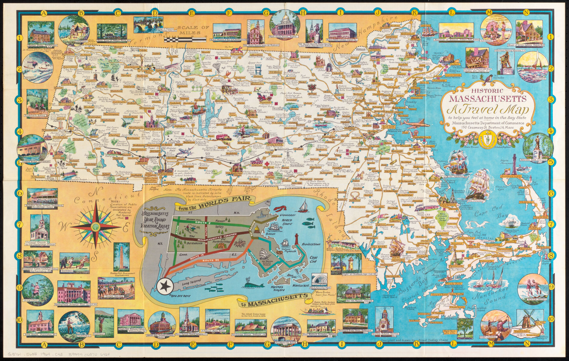
The state of Massachusetts commissioned this map as a way to advertise its tourist locations and important historical sites. It's interesting because each town on the map has its own fun fact, advertising at least one thing tourists can do in each city. Towns and cities that are not usually known as tourist destinations, such as Worcester, are highlighted here. The map's borders are also filled with other activities and sites in Massachusetts that couldn't be fit into the larger map. One example is Plymouth Rock, as seen on the bottom of the map. Although this map only dates back to 1964, it still reveals how people were informed of certain events/places to visit in their home state.
Rand Avery Supply Co New York, New Haven & Hartford Railroad : Old Colony system (1893)
This map advertises how people from Massachusetts, New York, New Haven, and Hartford can find their way to the coastal islands of Massachusetts: Nantucket and Martha’s Vineyard. The map not only shows the times when visitors can catch the Old Colony Line to both islands, it also portrays an accurate map of the surrounding area, including public transportation and the locations it serves. The idea that one could get to the islands of Massachusetts from states away in the late 19th century would have been worth advertising and been a luxury to many! This is another example of a map giving people extra information in order to sell a product and make the company appear more trustworthy to the customer.
John F Murphy Bird's eye view of Boston Harbor and south shore to Provincetown showing steamboat routes (1901)

This map similarly advertises numerous steamboat and train routes of the early 20th century. All steamboat advertisements featured today opted to include practical elements in their advertisements by providing a functional map, but there are some key differences in the rest of their approach. This map chose to center its focus on the Boston Harbor and the water surrounding the greater Boston area. Not only does it successfully point out the bays specific to the waterside towns surrounding Boston, it also includes a rough estimate of the steamboat’s path to places like Provincetown and Plymouth after departing from the Boston Harbor.
Geo H Walker and Co Map showing the routes of The Winthrop Steamboat Co (1896)
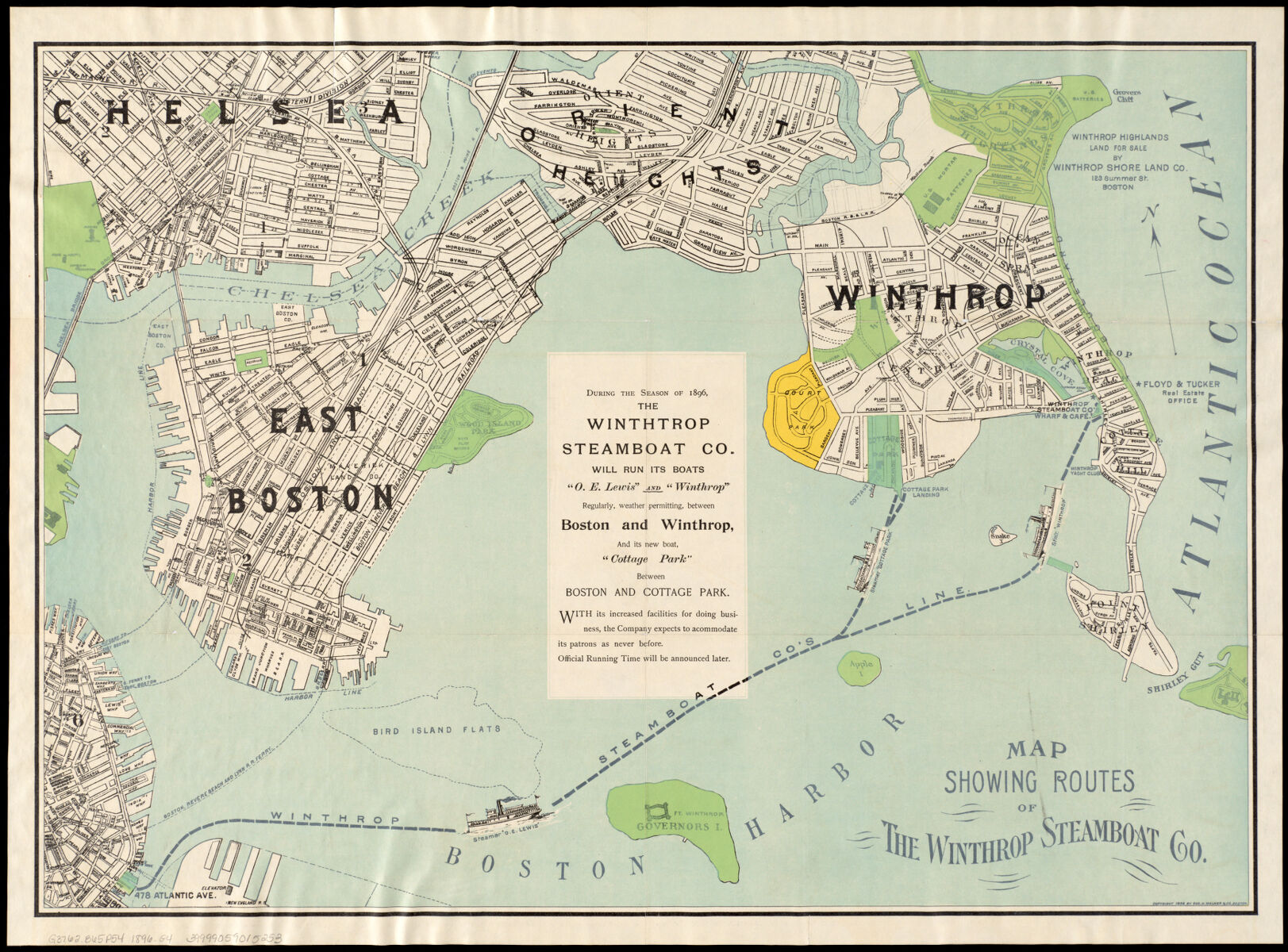
This map from the Winthrop Steamboat Company uses a unique perspective to offer a practical and visually exciting map. To show the extensive area their steamboats reach, this company decided to incorporate a view of the areas of Boston and Winthrop, where the steamboats were based. From East Boston, Orient Heights, and Chelsea. blue lines show how the ports gave commuters easy access to the town of Winthrop! Commissioned in the late 19th century, this map shows the different modes of transportation that were relied upon.
Richard Edes Harrison An aerial view of New York City showing how easily the weary traveler may reach the Herald Square Hotel wherein he will find the rest, comfort & hospitality to which he is entitled, even in this day and age (1932)
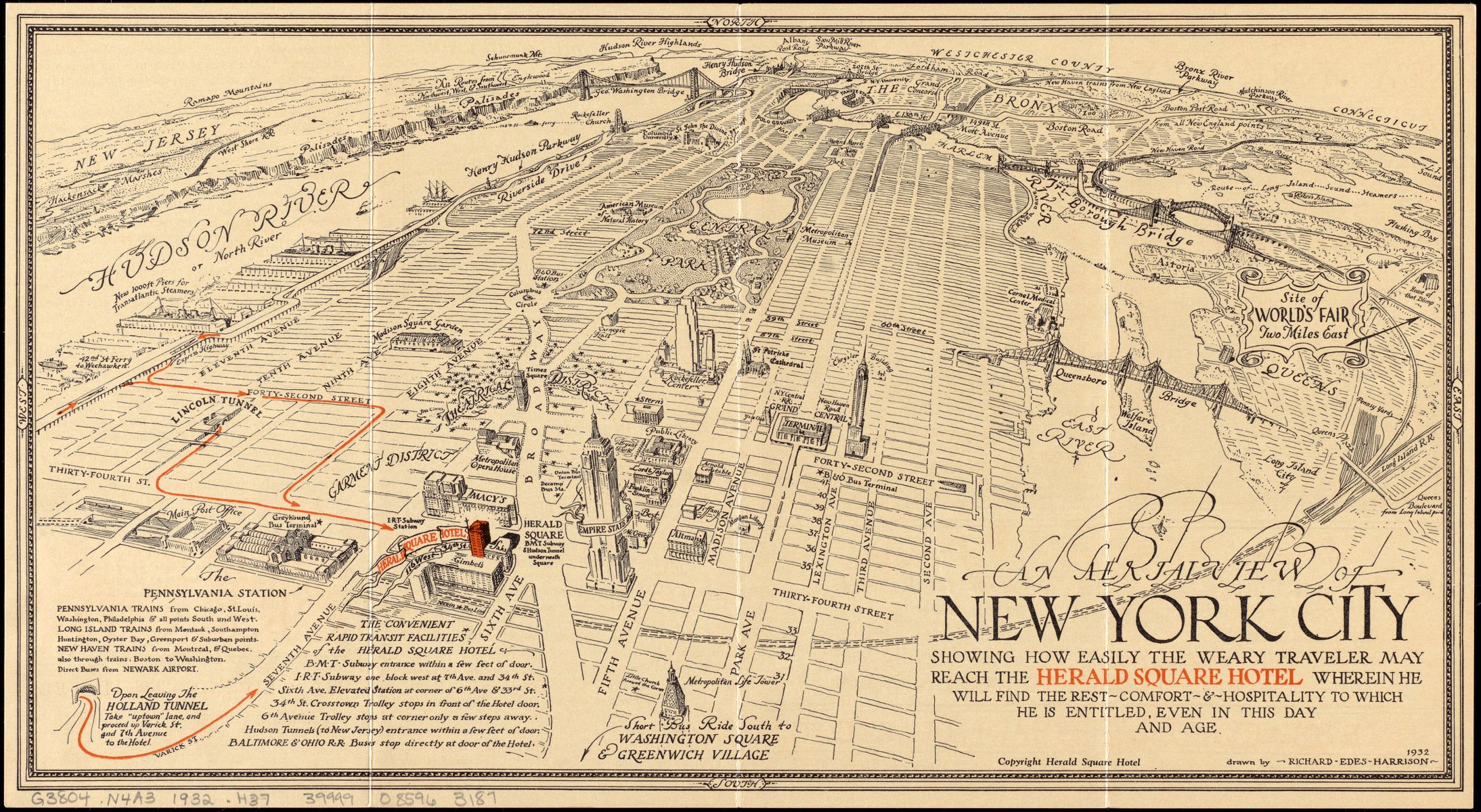
The map beautifully details Manhattan and even points out notable sites on the map, such as the Hudson River, Brooklyn Bridge, and the Empire State Building. However, it stands out in that it serves as both a functional map of NYC and as an advertisement for the Herald Square Hotel. The orange arrows leading to the hotel became the main focus of the map, in contrast with the black-and-white of the rest of the map. This was a captivating advertising tactic since maps were one of the main modes of finding and getting to events, entertainment spaces, restaurants, and other hospitality spaces- not only is this a functional map that could come in handy for a typical traveler, but it also subtly highlights its establishment.
James T Lloyd Lloyd's telegraph, railroad & express map of the whole United States & Canadas, from official information (1863)

This is a geographically accurate depiction of the Great Lakes area intended to advertise Lloyd’s (the cartographer) telegraph, railroad, and express mapping company. The ad shows off the company's vast presence throughout this region, with more than 200 railroads and ten telegraph lines. To make life even more accessible for the consumer, they also provided estimated service costs and where precisely they can be visited within this area. During the 19th century, a tool like this would have been helpful to anybody traveling through the Greater Lakes region who was unfamiliar with the territory.
Geo H Walker and Co Trolley wayfinder, birds eye view of trolley routes in New England (1904-05)
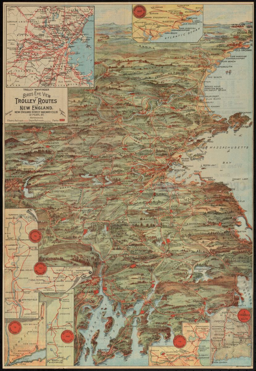
One mode of transportation not explicitly mentioned in this collection of maps is the trolley. The New England Street Railway Club commissioned this piece to advertise their trolley services across the New England area and provide their consumers with an accurate map that mentions the trolley stops. It's typical for these maps to act as a detailed guide, with information about the services they offered. The map highlights sections of New England that the trolley passes through and provides the price, distance, and scheduled timing of every trip. This type of ad heavily appealed to their audience as most people utilizing these types of transport are leisure travelers as well.
Our articles are always free
You’ll never hit a paywall or be asked to subscribe to read our free articles. No matter who you are, our articles are free to read—in class, at home, on the train, or wherever you like. In fact, you can even reuse them under a Creative Commons CC BY-ND 2.0 license.