We’re excited to welcome Claire Tratnyek to the team as our new Learning Resource Specialist. Claire is an accomplished academic, teacher, and museum educator. We sat down with Claire to learn more about her interests and future work at the Center.
Claire, we’re so excited to have you on board here at the Leventhal Map & Education Center. Tell us a little bit about your background—what led up to your new role with us?
My academic background is in history and anthropology, but my practical background is more than a decade of classroom teaching and curriculum development in Boston (K-12 and at Northeastern University), and museum education research at the Isabella Stewart Gardner Museum. I’m currently a PhD candidate in history at Northeastern, and I just wrapped up work on a major study at the Gardner. So I wear a lot of hats!
Tell us a little bit about your dissertation!
I am examining the history of segregated schooling in Boston since the 1970s, and using the neighborhood of East Boston as a case study that will (I hope!) provide a more inclusive framework for considering race and segregation in urban and educational spaces. I’ve been thinking about this subject for a few years and I’m so excited to see it come to fruition soon!
Do you have a favorite of the digital programs and tools we have available to the public right now?
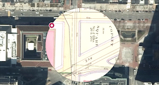
Atlascope, featuring an in-atlascope tour of the Boston Public Library throughout the years
I LOVE the Atlascope tool! I use it all the time with my undergraduates at Northeastern when I teach a History of Boston course as a way to make sense of the way space and time can be understood when thinking about the changes of urban spaces.
In my own research, I study Boston’s education history and I used Atlascope to fill in the gaps between records of Boston’s public schools about things like past site locations and name changes of the schools. I sometimes even used Atlascope to help me figure out when schools were founded by comparing atlases and noting when a school building appeared for the first time that otherwise went unnoted in the public record.
Every city needs to have an Atlascope version, but I really think San Francisco, Chicago, and New Orleans versions of Atlascope would be so interesting.
What is your earliest memory of maps?
I grew up in the Los Angeles area, and I remember my parents pulling out a Thomas Guide of SoCal every time we needed to go someplace we didn’t know. We’d get a new edition every few years that reflected the pretty much constant development in the area—even new freeways! So that’s how I learned to navigate, and it’s taken a long time for me to get comfortable with GPS directions rather than planning my driving route out on a Thomas Guide or some other kind of map.
You’re starting in the middle of Heaven & Earth: The Blue Maps of China. In your opinion, what’s a “must see item” in the exhibit?
That Prussian blue is so captivating! Both the folding geographical map from 1818 and the celestial map are beautiful informational objects—though for me they are art objects as well, since I can’t read any of the text! This exhibit provides a nice reminder of how maps as pieces of material culture can function in a multitude of ways.
What work at the Center are you looking forward to?
I love developing high quality, accessible, and engaging materials for teaching and learning with maps and other primary sources. I am most excited about learning more about the collections so that I can help educators and students bring these historical objects into conversation with contemporary questions and ideas.
Do you have a favorite map that you’ve found in the collections yet?
So far, I am completely in love with the 1775 British scrimshaw map of Boston on a powder horn—but ask me again each week and I bet I’ll have a new favorite every time!
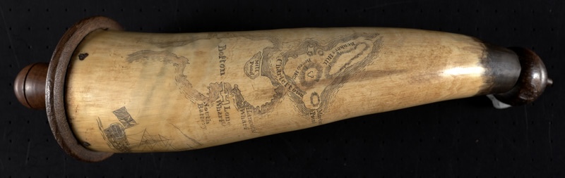
Powder horn with map of Boston and Charlestown, 1777
Our articles are always free
You’ll never hit a paywall or be asked to subscribe to read our free articles. No matter who you are, our articles are free to read—in class, at home, on the train, or wherever you like. In fact, you can even reuse them under a Creative Commons CC BY-ND 2.0 license.