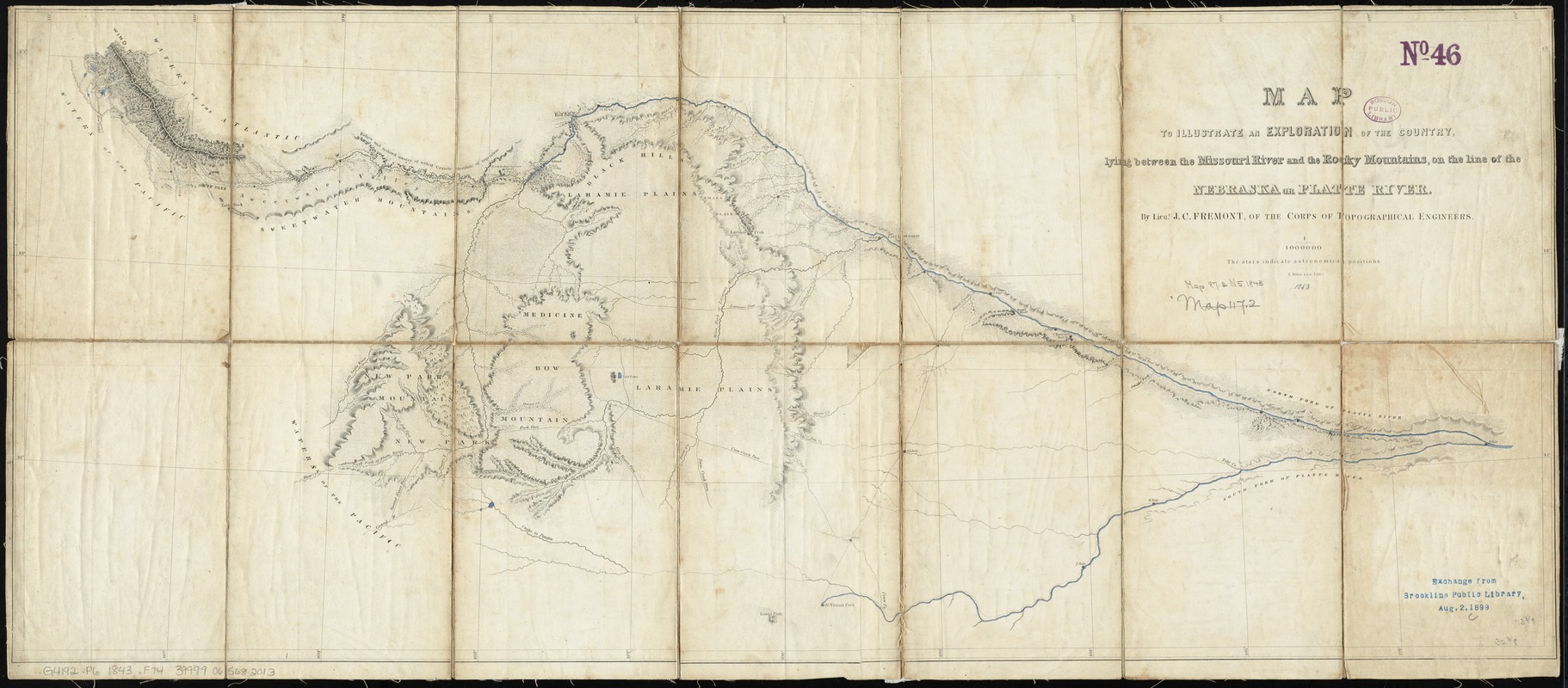
Map to illustrate an exploration of the country lying between the Missouri River and the Rocky Mountains, on the line of the Nebraska or Platte River
Item Information
- Title:
- Map to illustrate an exploration of the country lying between the Missouri River and the Rocky Mountains, on the line of the Nebraska or Platte River
- Creator:
- Frémont, John Charles, 1813-1890
- Name on Item:
-
by Lieut. J.C. Fremont, of the Corps of Topographical Engineers ; E. Weber & Co., Liths.
- Date:
-
[1843]
- Format:
-
Maps/Atlases
- Location:
-
Boston Public Library
Norman B. Leventhal Map Center - Collection (local):
-
Norman B. Leventhal Map Center Collection
- Subjects:
-
Platte River (Neb.)--Maps
Wyoming--Maps
Colorado--Maps
Nebraska--Maps
1842
- Places:
-
Colorado
Wyoming
Nebraska
- Extent:
- 1 map : hand col. ; 35 x 83 cm.
- Terms of Use:
-
No known copyright restrictions.
No known restrictions on use.
- Publisher:
-
Washington, D.C :
s.n.
- Scale:
-
Scale 1:1,000,000
- Language:
-
English
- Notes:
-
Relief shown by hachures.
Covers southern Wyoming, northern Colorado, and adjacent areas.
"Published in a Report on exploration of the country lying between the Missouri River and the Rocky Mountains, on the line of the Kansas and Great Platte rivers, By Lieut. J.C. Fremont ... Washington ... 1843 (Senate report no. 243, 27th Cong., 3d. Sess.)."
- Notes (date):
-
This date is inferred.
- Identifier:
-
06_01_011255
- Call #:
-
G4192.P6 1843 .F74
- Barcode:
-
39999065682013
- LCCN:
-
96688037