Angling in troubled waters = der fischfang im truben = la peche en eau trouble = la pesca nelle acque turbes : a serio-comic map of Europe
Item Information
- Title:
- Angling in troubled waters = der fischfang im truben = la peche en eau trouble = la pesca nelle acque turbes : a serio-comic map of Europe
- Title (alt.):
-
Serio-comic map of Europe
Fischfang im truben
Peche en eau trouble
Pesca nelle acque turbes
- Description:
-
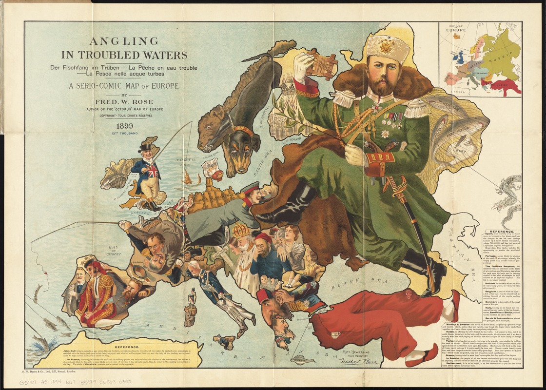
Political boundaries and power struggles define this work. The 19th-century “serio-comic map” caricaturizes each European country as a fisherman, holding a sack with its imperial catch, or about to lose what it has caught. Serving as an allegory for European colonial interference elsewhere, this type of “persuasive” map influenced and reflected popular opinion, much like a political cartoon.
- Creator:
- Rose, Fredk. W. (Frederick W.)
- Name on Item:
-
by Fred. W. Rose ; Matt. Hewerdine, from design by Fred. W. Rose.
- Date:
-
[ca. 1899]
- Format:
-
Maps/Atlases
- Location:
-
Boston Public Library
Norman B. Leventhal Map Center - Collection (local):
-
Norman B. Leventhal Map Center Collection
- Subjects:
-
Europe--Politics and government--Maps
Europe--Maps
- Places:
-
Europe
Europe
- Extent:
- 1 map : col. ; 50 x 71 cm., folded in cover 20 x 14 cm.
- Terms of Use:
-
No known copyright restrictions.
No known restrictions on use.
- Publisher:
-
London :
G.W. Bacon & Co.
- Scale:
-
Not drawn to scale
- Language:
-
English
- Notes:
-
National political attitudes are represented by caricatures of people, animals, etc.
Includes text and inset of "Key map of Europe."
- Notes (exhibitions):
-
Exhibited: "Crossing Boundaries: Art // Maps" organized by the Norman B. Leventhal Map & Education Center at the Boston Public Library, 2018-2019.
- Identifier:
-
06_01_011037
- Call #:
-
G5701.A5 1899 .R67
- Barcode:
-
39999065680355


